
St Aubin
Latitude: 49° 10'N
Longitude: 02° 10'W
Country: Channel Islands
Ownership: States of Jersey
Type: Municipal
Usage: Leisure, Fishing
Contact name: Capt. Howard Le Cornu, Harbourmaster
Address: Maritime House, La Route du Port Elizabeth, St Helier, Jersey JE1 1HB
Telephone no: 01534 447788
E-mail: jerseyharbours@gov.je
Website: www.portofjersey.je/Jerse...bours.aspx
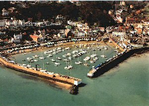
About St Aubin
The harbour at St Aubin was completed in 1700, and with the protection of St Aubins Fort (built in the 1540s), it attracted most of the Islands shipping. The merchants who used this haven got rich from their trading, and built some fine houses in the area. Their wealth came from trade across the Atlantic, especially the cod fishing and the links with Newfoundland. The present harbour was built early in the 19th century, but gradually merchants were found to prefer the new facilities being created at St Helier.St Aubin is a very sheltered drying harbour. Visiting yachts should only enter one hour either side of high water and moor up on the wall immediately to starboard.
Yachts can also dry out on the beach north and north east of the moorings outside the harbour. A deep water anchorage much used by locals is at Belcroute Bay one mile to the south west.
Return to Area Map