
Paignton
Latitude: 50° 26'N
Longitude: 03° 33'W
Country: England
Ownership: Torbay District Council
Type: Municipal
Usage: Leisure, Fishing
Address: Paignton Harbour Office, South Quay, Roundham Road, Paignton, Devon TQ4 6DT
Telephone no: 01803 557812
E-mail: marine.services@torbay.gov.uk
Website: www.torbay.gov.uk/index/l...arbour.htm
About Paignton
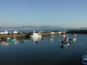
Paignton Harbour nestles on the western shores of Tor Bay situated midway between Torquay and Brixham harbours. Its understated beauty and authentic fishing haven feel are often overlooked by visitors to the area and even some locals.The harbour was established in the 18th Century, some 500 years before Queen Victorias accession to the throne. The local Council has managed the harbour since 1935. Paignton was a thriving fishing harbour for many years and some of the old traditions of seamanship are kept alive and passed on through generations of Paigntonians. Today the harbour remains a hive of activity, especially during the summer months and a vast range of different users enjoy the benefits of this unassuming maritime gem.
The harbour dries out at low tide and is well known for having an unconventional fairway approach. Unlike nearly all the other harbours in Great Britain the approach to Paignton is made on the port side of the fairway and not the starboard side. This unusual and interesting feature is marked by a unique looking seasonal buoy and provides for a much safer harbour approach.
Alongside berthing is limited but visiting craft may lie alongside East Quay subject to certain conditions and prior consent. There are, however, two visitors' moorings which cater for vessels up to 20. Please contact the Harbour Office for availability, as these facilities can be booked in advance.
The are two slipways in regular use within the harbour, the primary facility being located on East Quay, whilst the slipway on West Quay is of less gradient. The launch and recovery of all vessels from these facilities is strictly by permission from the harbour office.
Return to Area Map