
Strangford
Latitude: 54° 22'N
Longitude: 05° 32'W
Country: N. Ireland
Ownership: Department for Regional Development
Type: Private
Usage: Leisure, Commercial
Contact name: Mr Derek Pedlow, Ferry Manager
Telephone no: 028 44 881637
E-mail: derek.pedlow@drdni.gov.uk
About Strangford
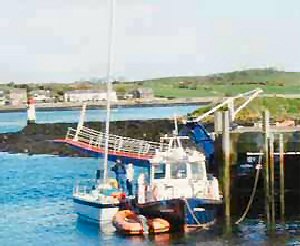
Strangford appears as one of the 'Ports of Ulster' in 1281. It continued to prosper as the trading port, especially with North Wales and by the end of the 18th Century it ranked eighth amonst the ports of Ireland. By the mid 19th Century, however, it had been overtaken in prosperity by neighbouring Portaferry on the opposite side of the entrance to Strangford Lough.A double cove constitutes its harbour. There are two quays and a wharf, about 100 feet long, with a depth of 10 feet alongside, at which small coasters can lie at all states of the tide.
The Government's Roads Service is currently responsible for the operation and maintenance of the Strangford Lough ferry service which provides an essential transport link for cars, commercial vehicles and foot passengers across the fast flowing currents of the southern end of the Lough between Portaferry and Strangford. The alternative road journey is approximately 64 kilometres and takes about 70 minutes by car.
The service has been in operation since 1969 and runs for approximately 16 hours each day, 364 days per year. The ferry route is approximately 0.6 nautical miles with a typical crossing time of about eight minutes. The service normally operates with one vessel which leaves each slipway at 30 minute intervals; from Strangford on the hour and half hour and from Portaferry at quarter past and quarter to each hour. At certain busy periods, such as Bank Holidays and summer weekends, both vessels are operated off schedule to meet the extra passenger demand.
Return to Area Map