
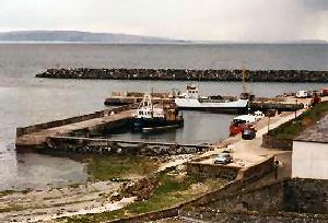
Church Bay (Rathlin Island)
Latitude: 55° 17'N
Longitude: 06° 11'W
Country: N. Ireland
Ownership: Moyle District Council
Type: Municipal
Usage: Leisure, Fishing, Ferry Terminal
Website: www.moyle-council.org/ser...ils/?id=61
About Church Bay (Rathlin Island)
Rathlin, Northern Island's only inhabited island, is reached by ferry from Ballycastle. It docks at Church Bay and there are at least two return sailings per day all year round with additional sailings in the summer months. The six mile journey takes 45 minutes.Rathlin is six miles north of Ballycastle, Co. Antrim and fourteen miles from the Mull of Kintyre in Scotland. It has a winter population of about a hundred people, boosted by many visitors - divers, birdwatchers, botanists, sea-anglers.
Until the 1940s Rathlin used to export kelp from Church Bay. Seaweed was collected and put into stone kilns and burned until it turned into a "boiling mess". There were up to 150 kelp kilns at one time and the kelp was used to produce soda and iodine.
Around Church Bay there is a diving centre; a popular activity due to the number of wrecks in and around the bay.
Return to Area Map