
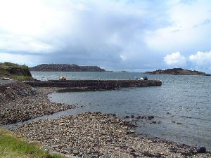
Bunessan
Latitude: 56° 20'N
Longitude: 06° 17'W
Country: Scotland
Ownership: Argyll & Bute Council
Type: Municipal
Usage: Leisure, Fishing
Contact name: Mr Neil Brown, Area Roads & Amenity Manager
Address: Kilbowie House, Gallanach Road, Oban, Argyll, PA34 4PF
Telephone no: 01631 562125
E-mail: neil-brown@argyll-bute.gov.uk
About Bunessan
Bunessan is located on the Ross of Mull (Ross meaning 'peninsular').The pier was constructed from the local granite in 1846, and was known as "The Maize Pier", as much of the work on the pier was done by local men who had to work there in return for the emergency food supplies given after the potato famines of previous years. Those unable or not willing to work joined the emigrants from the area.
Prior to the building of the pier, boats anchored in the bay and shuttled their cargo ashore in small boats. After the opening of the new pier, larger boats could tie up and unload more quickly and in greater safety.
The largest vessel to come in to the pier was the Dunara Castle, which unloaded 20 tons of cargo each week. Access to the pier was along a track following the shore until 1939, when the new road was completed.
Today the pier is used by the local fishing vessels all the year round, and by visiting yachts during the summer months.
Return to Area Map