
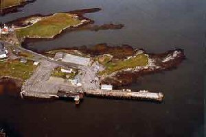
Lochmaddy
Latitude: 57° 36'N
Longitude: 07° 09'W
Country: Scotland
Ownership: Comhairle Nan Eilean Siar
Type: Municipal
Usage: Commercial, Ferry Terminal
Contact name: Calum Macleod, Harbour Master
Address: Technical Services, Comhairle Nan Eilean Siar, Balivanich, Benbecula, HS7 5LA
Telephone no: 01870 602425
E-mail: calum-macleod@cne-siar.gov.uk
Website: www.cne-siar.gov.uk/harbo.../index.htm
About Lochmaddy
Lochmaddy Pier, North Uist, is the port for the ferry link to Uig, Skye. The ferry berth on the south side of the pier is 115 metres long, incorporating a linkspan at the inner end capable of 120 tonnes loading. The depths alongside the south berth vary from -4.0m CD at the linkspan to -6.5m CD at the seaward end. The berth has a 5.0 tonne Ro/Ro and 3.5 tonne Lo/Lo explosives licence. The north berth has 60 metres of berting face with a general depth of 4.0 CD. The tidal range is 4.1m.Return to Area Map