
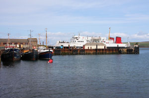
St Margaret's Hope
Latitude: 58° 50'N
Longitude: 02° 56'W
Country: Scotland
Ownership: St Margaret's Hope Pier Trust
Type: Trust
Usage: Fishing, Ferry Terminal
Contact name: Gina Brown, Piermaster
Address: Thorshaven, St Margaret's Hope, Orkney, KW17 2SP
Telephone no: 01856 831897 / 07912063637
E-mail: smhpt-piermaster@hotmail.com
Website: www.orkneycommunities.co....PIERTRUST/
About St Margaret's Hope
St Margaret's Hope is the third largest settlement in Orkney and sits at the head of a sheltered bay at the northern end of South Ronaldsay. The village has become a busier place than it used to be following the opening of a car ferry link by Pentland Ferries in 2001. A new fast catamaran, the Pentalina was introduced in December 2008, providing a 45 minute service to and from the Scottish mainland at Gill's Bay.The village's growth owed much to the establishment of a herring fishery here in the early 1800s, and this was consolidated through the development of a naval base in Scapa Flow during the two world wars. Fishing has diminished in importance, but the harbour, boatyard and slipway areas remain very active, even when the ferry isn't berthed.
Return to Area Map