
Petticowick
Latitude: 55° 55'N
Longitude: 02° 10'W
Country: Scotland
Website: www.diveinthepink.ukdiver...cowick.htm
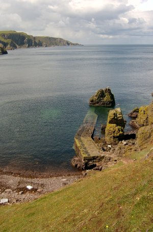
About Petticowick
Petticowick is a former salmon fishing station, situated in a small cove around the headland to the north-west of St Abbs harbour. Access is by a small road between Scoutscroft and St Abbs village; the road is single track and parking is limited at the cove. The path down to the beach is steep and dangerous, following a landslip.The jetty is showing signs of decay, but diving organisations, who use the jetty to research a nearby wreck, are keen to restore it.
Return to Former Harbours Map