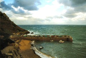
Bonne Nuit
Latitude: 49° 15'N
Longitude: 02° 07'W
Country: Channel Islands
Ownership: States of Jersey
Type: Municipal
Usage: Leisure, Fishing
Contact name: Capt. Howard Le Cornu, Harbourmaster
Address: Maritime House, La Route du Port Elizabeth, St Helier, Jersey JE1 1HB
Telephone no: 01534 447788
E-mail: jerseyharbours@gov.je
Website: www.portofjersey.je/Jerse...bours.aspx
About Bonne Nuit
Bonne Nuit Bay is a tidal harbour that lies on Jersey’s north coast. It houses around 45 small craft and fishing vessels. This small harbour was constructed in 1872 by the States of Jersey as a shelter for the inshore fishing boats, as well as a facility for exporting the high quality granite to be found nearby at Mont Mado.Although it is a tidal harbour, anchoring is possible if your vessel is unable to take the ground. Vessels can be anchored just outside the harbour in the deeper water areas to the west of the pier. The tidal streams are very strong at spring tides and any wind can cause bad overfalls near the headlands.
Return to Area Map

