
Image © Tim Geaney
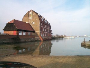
Ashlett Creek
Latitude: 50° 50'N
Longitude: 01° 20'W
Country: England
Type: Unknown
Usage: Leisure
About Ashlett Creek
Salt production was important here from Saxon times until the 19th century when corn milling became Ashletts principal industry. Flat bottomed sailing barges working the tides handled by perhaps only two men and a boy could negotiate the creek with relative ease; the last one came in 1932. The Hollies, now a private house, was at one time the coastguard house. Today the creek is a haven for small sailing craft.The creek is sheltered and accessible to boats up to about 1.5m draft (mid to high tide). You can moor against the quay at the head of the creek but will dry out.
Return to Area Map